Leonida Map Theories That Could Actually Be True
A deep dive into the community mapping project and how big Leonida truly is compared to Los Santos.
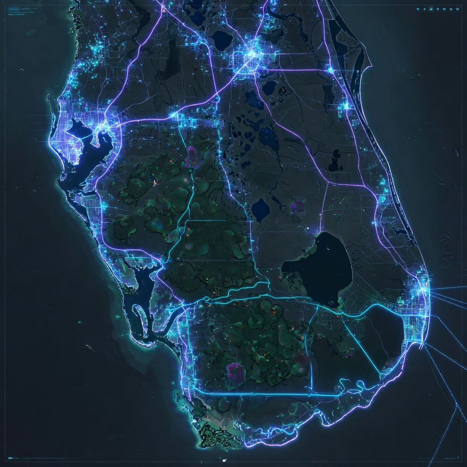
In the entire history of interactive entertainment, no virtual landmass has been subjected to the rigorous, forensic investigation currently focused on the State of Leonida. For years, a highly dedicated syndicate of cartographers, math experts, and community researchers—famously spearheaded by the Vice City community mapping project—have painstakingly stitched together the ultimate geographical layout of Grand Theft Auto VI.
By cross-referencing exact world coordinates from development leaks, calculating cloud shadows, measuring highway overpass angles in Trailer 1, and utilizing real-world Florida photogrammetry, this community initiative has generated a deeply accurate preview of what awaits us in Fall 2025.
1. Map Size: Leonida vs. Los Santos (GTA V)
The absolute most frequent question asked by the global gaming community is: How big is the GTA 6 map compared to GTA 5? Based on calculated rage engine coordinate grids, the current explorable footprint of Leonida is estimated to be 2.1x to 2.5x larger than the combined landmass of Los Santos and Blaine County.
The Scale & Density Advantage:
Dominated primarily by the Mount Chiliad mountain range and the Grand Senora Desert, with a single highly dense metropolitan hub located in the south.
Sprawling multi-city ecosystem featuring massive interior explorable space, expansive waterways, island chains, and two distinct major urban centers.
2. The Three Anchor Regions of Leonida
Unlike Los Santos, which acted as a lone island metropolis, the State of Leonida is built upon a dynamic, interconnected triad of distinct socio-economic and ecological biomes.
The ultimate neon playground. Featuring the breathtaking Starlet Tower, Ocean Beach boardwalks, high-end downtown highrises, and the sprawling Leonida International Airport (MIA).
Situated along the western seaboard (heavily parodying Tampa and Panama City). Known for gritty industrial ports, local dirt tracks, suburban strip malls, and heavy VCPD presence.
Expansive southern island archipelagos linked by monumental highway bridges, cutting directly through the deep, gator-infested marshlands of the Leonida Everglades.
3. Unprecedented Explorable Interiors
A critical element of the community mapping project focuses not just on horizontal landmass, but vertical density. According to credible industry leaks and patent filings by Take-Two Interactive, GTA 6 utilizes an advanced AI-driven interior generation system.
Players can expect a massive leap in enterable structures—moving far beyond the simple Ammu-Nations and clothing shops of GTA V. Confirmed and speculated interiors include multi-level nightclubs, operational pawn shops, active diners, sprawling supermarkets, suburban motel rooms, and towering apartment complexes.
Google Search FAQ: GTA 6 Map Size & Theories
How big is the GTA 6 map compared to GTA 5?
Based on forensic coordinate calculations by the community mapping project, the GTA 6 map (Leonida) is estimated to be 2.1x to 2.5x larger than GTA 5's Los Santos.
Will there be multiple cities in GTA 6?
Yes. Official trailer footage has explicitly confirmed at least two major distinct metropolitan municipalities: Vice City (Miami) and Port Gellhorn (Tampa/Panama City).
Is Tampa or Orlando in GTA 6?
Port Gellhorn serves as the western anchor city heavily mirroring Tampa, while community theories suggest an inland central region reflecting the theme park capital of Orlando.
Are the Bahamas or Cuba in GTA 6?
While early project leaks (codenamed Project Americas) suggested fully explorable South American and Caribbean islands, current confirmed mapping focuses heavily on the Florida mainland and the Gator Keys archipelagos.
Stay Updated With Verified Intel
Don't get fooled by clickbait rumors. Bookmark our page and check back weekly for absolute confirmed facts.
View Countdowns